The Surprising Reason Engineers Are Switching to Drone Site Inspections
You're standing on the edge of a construction site, a wind farm, or a sprawling industrial facility. Somewhere up on that roof, inside that tower, or along those miles of pipeline… there's a problem. You just can't see it yet.
That's the terrifying reality most project managers, engineers, and property owners live with every single day. Traditional inspection methods are slow, expensive, dangerously outdated and in many cases, they literally can't reach where the damage is hiding. And by the time someone does find it? The repair bill has quietly tripled.
Here's the thing though: drone site inspection has completely changed this game. And if you're not using it yet or don't fully understand what it can do, you're leaving money, safety, and peace of mind on the table.
Let's break this down in a way that actually makes sense.
The Dirty Secret About Traditional Site Inspections Nobody Wants to Admit
You know the drill. Someone books an inspection. A crew shows up with scaffolding, ladders, and safety gear. They spend days …. sometimes weeks …. manually checking structures. They file a report. You pay a massive invoice. And somehow, critical issues still get missed.
It's not always negligence. Sometimes it's just physically impossible for a human to get close enough, high enough, or into a confined enough space to spot every crack, every corrosion point, every structural anomaly.
When "Good Enough" Inspection Becomes a Liability Nightmare
Think about a wind turbine blade 80 meters in the air. Or a bridge undercarriage over a rushing river. Or a solar farm spanning acres of land under scorching heat. Traditional inspection means either putting workers in danger or simply not inspecting those hard-to-reach areas at all.
Most project owners don't realize this until something fails. And when it does …. structurally, operationally, or in terms of safety compliance, the consequences aren't just expensive. They can be catastrophic.
This is exactly where drone inspection services step in. And once you understand what they can actually do, you'll wonder how anyone ever managed without them.
What Drone Site Inspection Actually Is, And Why It's Nothing Like You Imagine
Let's clear something up right away. A drone site inspection isn't just a fancy aerial camera flying around taking pretty photos. That's… embarrassingly underselling it.
Modern UAV site inspection combines high-resolution imaging, thermal sensors, LiDAR mapping, photogrammetry, and AI-powered data analysis into a single, rapid, highly accurate workflow. We're talking about the kind of detail that used to require an entire team of specialists, weeks of access preparation, and serious health and safety planning.
Now? It takes hours. Sometimes less.
The Technology Behind the Magic
Here's what's actually happening during a professional aerial site inspection:
A drone (often multiple drones operating in coordination) flies a pre-programmed or manually controlled path across your site. As it moves, it's simultaneously:
Capturing 4K or higher resolution video and stills
Running thermal imaging to detect heat anomalies invisible to the naked eye
Building 3D point clouds using LiDAR for precise structural measurements
Collecting GPS-tagged data for geo-referenced mapping
In some cases, running real-time AI analysis to flag anomalies immediately
The resulting data …. all of it …. gets processed through specialized drone inspection services software to produce reports that are frankly more accurate and more actionable than almost anything traditional methods can produce.
This isn't science fiction. This is happening on job sites, solar farms, power grids, and construction projects right now.
Why Construction Site Drone Inspection Is Becoming Non-Negotiable
The construction industry has historically been resistant to change. And honestly? You can understand why. When deadlines are tight, budgets are squeezed, and every delay costs money, nobody wants to experiment with new processes.
But construction site drone inspection isn't an experiment anymore. It's a proven, ROI-positive tool that leading contractors are using as standard practice — not because it's trendy, but because it genuinely solves problems that traditional methods can't.
Progress Monitoring That Doesn't Slow You Down
Imagine being able to document the exact state of your entire construction site every single day — without a single person leaving their desk. Drone-based site inspection makes this possible.
Regular aerial surveys capture detailed visual records of construction progress. These become invaluable for:
Verifying that work matches plans and specifications
Catching deviations before they become expensive corrections
Providing photographic evidence for contract disputes
Keeping remote stakeholders and clients informed in real time
And because drones can cover an entire site in a fraction of the time it would take a human inspection team, this kind of comprehensive monitoring is actually affordable. Which leads us to something important…
The Hidden Financial Case for Drone Surveys
Yeah… this is where most people start paying close attention.
The average cost of a drone site inspection for a mid-sized construction project is typically a fraction of what traditional inspection methods cost. Factor in the time saved, the reduction in work stoppages, the elimination of scaffolding hire costs, and the early detection of issues that would otherwise spiral into major reworks and the ROI becomes almost embarrassingly obvious.
One missed crack in a foundational element. One undetected water ingress point. One structural alignment issue was spotted three months too late. Any one of these can cost more to fix than an entire year's worth of drone inspection services.
Most project owners don't realize this until it's too late.
Industrial Drone Inspection: The Sectors That Can't Afford to Get This Wrong
Not every industry approaches drone site inspection with the same stakes. But some sectors, where infrastructure failure means lost lives, environmental disasters, or critical service outages, have adopted industrial drone inspection faster than almost any other technology in recent memory.
Power Lines, Pipelines, and the Infrastructure Nobody Sees
Power line inspection using drones has become standard practice for major energy utilities. The alternative, putting workers in cherry pickers alongside high-voltage lines, or shutting down sections of the grid for manual inspection is dangerous, disruptive, and expensive.
Drones equipped with thermal and multispectral cameras can identify hotspots, damaged insulators, vegetation encroachment, and structural issues along miles of transmission lines in a single flight. Infrastructure inspection with drones like this has genuinely transformed how utilities manage their assets.
The same logic applies to pipelines. Aerial inspection can detect ground subsidence, right-of-way encroachments, and surface-level anomalies along routes that might otherwise require teams of people on foot or in vehicles, traveling through remote, sometimes inaccessible terrain.
Solar Farms: Finding What the Eye Completely Misses
Here's one that surprises people. Solar panels look fine. But underneath or within them, cells can be failing silently, underperforming, generating heat anomalies, losing efficiency and you'd never know just by looking.
Thermal drone inspections of solar installations identify failing cells, bypass diode issues, and string-level faults across hundreds or thousands of panels in a single flight. Without drones, diagnosing a large solar farm at this level would take weeks of manual testing and potentially huge revenue losses from undetected underperformance.
Professional drone survey and inspection for solar assets is genuinely one of the highest-ROI inspection applications in any industry right now.
Wind Turbines: When Height Makes Inspection Impossible Without Drones
Wind turbine blade inspection is probably the single clearest example of a problem that drones have essentially solved. Blades are enormous, spinning components under constant mechanical stress. Cracks, erosion, leading edge damage, lightning strike marks, these need to be found early or they become catastrophic failures.
Before drones, inspecting a blade meant either rope access (dangerously slow and expensive) or pulling the blade down entirely (operationally devastating). Automated drone inspections with specialized blade inspection software have cut inspection times from days to hours while improving detection rates dramatically.
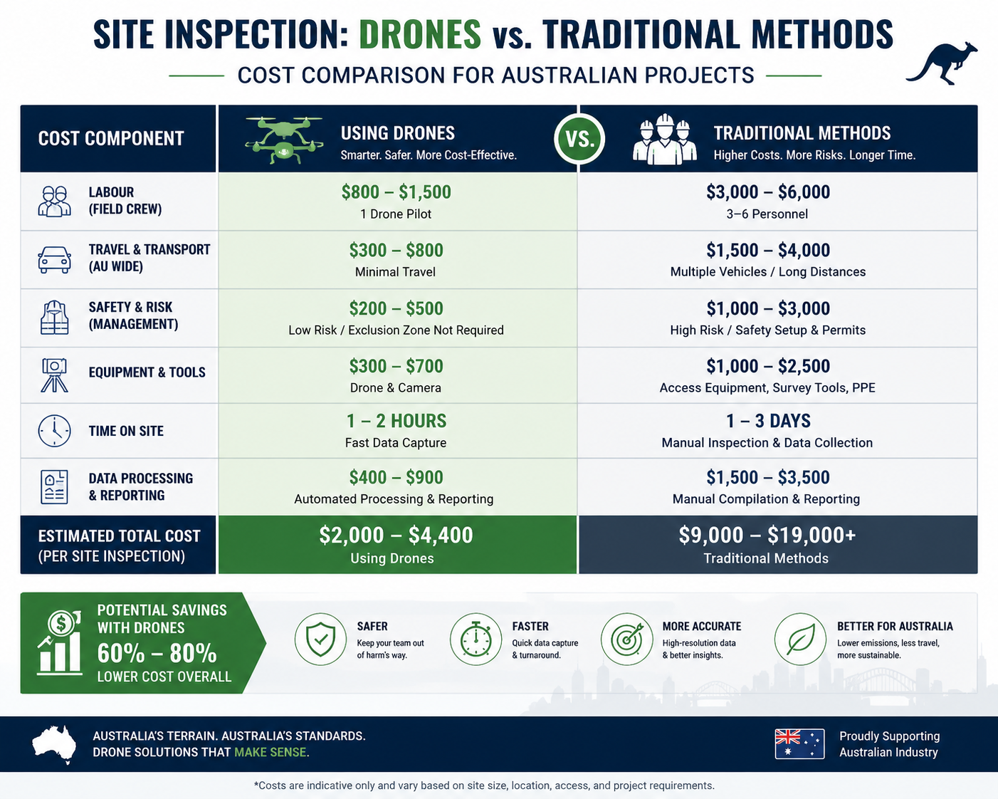
Site Inspection Using Drones vs. Traditional Methods: The Honest Comparison
Let's be direct about this, because a lot of companies still hedge when asked to compare site inspection using drones against conventional approaches. Here's the real picture:
Speed
Traditional inspection: days to weeks, depending on site complexity, access requirements, and the number of specialists needed.
Drone inspection: hours to a day. Sometimes less for smaller sites.
This isn't a marginal improvement. It's a fundamental shift in operational tempo.
Safety
Sending workers up scaffolding, onto rooftops, into confined spaces, or along high-voltage infrastructure is one of the leading causes of workplace fatalities in construction and industrial sectors. Every time you eliminate that requirement by using a drone instead, you're not just saving money, you're potentially saving a life.
UAV site inspection keeps humans on the ground while the drone takes the risk. This point alone would justify the technology even if everything else were equal.
Data Quality
This one genuinely surprises people. Many assume that a human inspector walking around with eyes and hands will produce better information than a drone. In many cases, they're wrong.
A drone with thermal cameras, photogrammetry software, and AI-assisted anomaly detection often catches things a human eye simply misses,especially at scale, in low-light conditions, or in situations where access limitations compromise the quality of a manual inspection.
Cost
Direct cost comparison generally favors drones significantly for medium to large sites. But even when upfront costs are comparable, the downstream benefits, earlier problem detection, reduced work disruption, comprehensive documentation, make the financial case overwhelming.
Automated Drone Inspections: The Future That's Already Here
Something that even well-informed project managers sometimes don't realize: automated drone inspections aren't a future capability. They're happening now.
Modern systems can fly pre-programmed inspection routes autonomously, process the resulting data through AI models trained to detect specific defect types, and produce structured reports, all with minimal human oversight. For facilities that require regular inspection cycles (power plants, pipeline networks, large industrial complexes), this creates an inspection cadence that would be economically impossible with any traditional approach.
What the Data Actually Looks Like
The output from a professional drone-based site inspection isn't just a folder of photos. It's structured, geo-referenced, and actionable.
Typical deliverables include:
Orthomosaic maps (seamlessly stitched aerial images with GPS accuracy)
3D models from photogrammetry data
Thermal anomaly reports with precise location tagging
Defect catalogues with severity classifications
Progress comparison overlays showing change over time
Integration with BIM (Building Information Modeling) platforms
This is the kind of data that used to require multiple specialist teams, significant budget, and weeks of work. Professional drone survey and inspection now delivers it routinely, quickly, and at a price point that makes comprehensive monitoring genuinely accessible.
Warning Signs Your Current Inspection Process Is Costing You More Than You Think
Be honest with yourself here for a moment.
If any of these sound familiar, your inspection approach has a problem:
You've had surprises during construction, issues that weren't caught until they required expensive rework
Your inspection records are inconsistent, incomplete, or hard to cross-reference
You've had near-misses or actual incidents involving workers doing inspection tasks in dangerous conditions
You're not conducting inspections as frequently as you know you should because they're too disruptive or too expensive
Remote stakeholders and clients are frustrated with the quality or timeliness of site reporting
You've discovered defects in assets, roofs, panels, turbines, pipelines, that had clearly been developing for a long time undetected
Any one of these points to a gap in your inspection capability that drone site inspection is specifically designed to fill.
Solutions You Can Try Before Things Get Worse
Whether you're managing a construction project, overseeing an industrial facility, or simply trying to get ahead of potential asset failures, here's a practical framework:
Start with a pilot inspection. Most professional drone inspection providers will conduct a demonstration or pilot inspection at reduced cost. This gives you real data about your site without a major commitment. Use it.
Audit your current inspection frequency. Look at your last 12 months of inspection records. How many gaps are there? How many areas weren't covered? How many reports lack the detail to actually drive decisions? This audit will make the case for drone services on its own.
Identify your highest-risk assets first. Don't try to do everything at once. Identify the components or areas of your site where failure would be most costly or dangerous and start there. Roofs, structural connections, high-voltage components, aging pipelines. These are your priority zones.
Get thermal capability for anything energy-related. If you're managing solar, power infrastructure, or industrial equipment, thermal drone inspection isn't optional, it's the only way to detect the failure modes that matter most. Make sure your inspection provider offers this.
Request raw data, not just reports. A reputable professional drone survey and inspection company will give you access to the underlying data, not just a summary PDF. This data is valuable for trend analysis over time, for integration with your asset management systems, and for your own records in case of disputes or audits.
Establish a regular inspection schedule. The biggest gains from drone inspection come from consistency. A single inspection tells you where things are today. Regular inspections tell you how things are changing and that's when you can actually get ahead of problems.
Know when to escalate. Drone inspection identifies issues. It doesn't always resolve them. Make sure you have a clear process for routing inspection findings to the right people, structural engineers, maintenance teams, specialist contractors, so data turns into action.
-
A drone site inspection uses unmanned aerial vehicles (UAVs) equipped with cameras, thermal sensors, and other instruments to survey and assess structures, land, or assets from the air. The drone captures data, imagery, thermal readings, LiDAR point clouds, which is then processed to produce detailed inspection reports. It replaces or supplements traditional manual inspection methods.
-
Costs vary based on site size, complexity, sensor requirements, and reporting scope. A basic aerial survey for a small to medium construction site might start from a few hundred dollars, while comprehensive industrial inspections with thermal imaging and 3D modelling can run into several thousands. Even at the higher end, most clients find the cost significantly lower than equivalent traditional inspection methods and the data quality is often better.
-
For many inspection types, yes, and in some cases, drones are actually more accurate than human inspection, particularly for large areas, hard-to-reach locations, and anomaly types detectable only by thermal or multispectral sensors. For complex structural assessments that require physical testing, drones typically complement rather than fully replace specialist human inspectors.
-
Construction sites, industrial facilities, power infrastructure (transmission lines, substations), renewable energy assets (solar farms, wind turbines), oil and gas pipelines, bridges and roads, commercial rooftops, and large land areas are all excellent candidates. Essentially, any site where coverage, height, scale, or hazardous conditions make traditional inspection difficult or expensive.
-
It depends heavily on site size and inspection type. A standard construction site progress inspection might take a few hours. A large solar farm thermal inspection could take a full day. A multi-structure industrial complex might require several days of flights. In almost every case, the same inspection by traditional methods would take significantly longer.
-
Professional drone inspection providers operate under aviation authority regulations (FAA in the US, CAA in the UK, DGCA in India, and equivalent bodies elsewhere). This includes obtaining necessary flight permissions, maintaining required certifications, carrying appropriate insurance, and following airspace rules. Reputable providers will handle all compliance requirements and will not fly where regulations prohibit it.
-
Depending on the scope, you might receive: high-resolution photos and video, orthomosaic aerial maps, 3D models, thermal anomaly reports, LiDAR point clouds, defect catalogues with GPS coordinates, and comparison reports showing change over time. The deliverables should be clearly defined before engagement.
Plexs — Always here with ideal designs.